


La Combe de Curnier

Nathy8913
User
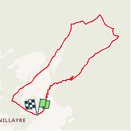

Length
9.2 km

Max alt
1066 m

Uphill gradient
633 m
Km-Effort
17.7 km

Min alt
427 m

Downhill gradient
637 m
Boucle
Yes
Creation date :
2019-06-12 12:38:47.35
Updated on :
2019-11-27 13:08:04.198
--
Difficulty : Easy

FREE GPS app for hiking
 SityTrail
IGN / Geographical institutes
SityTrail Plus
The world is yours!
About
Trail On foot of 9.2 km to be discovered at Provence-Alpes-Côte d'Azur, Vaucluse, Bédoin. This trail is proposed by Nathy8913.


Positioning
Country:
France
Region :
Provence-Alpes-Côte d'Azur
Department/Province :
Vaucluse
Municipality :
Bédoin
Location:
Unknown
Start:(Dec)
Start:(UTM)
677150 ; 4889006 (31T) N.
Comments