
19.06.13.Munster

ROPPJP
User
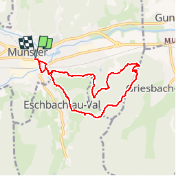

Length
7.3 km

Max alt
591 m

Uphill gradient
247 m
Km-Effort
10.6 km

Min alt
372 m

Downhill gradient
247 m
Boucle
Yes
Creation date :
2019-06-13 07:25:24.149
Updated on :
2019-06-13 09:38:20.566
2h10
Difficulty : Very easy

FREE GPS app for hiking
 SityTrail
IGN / Geographical institutes
SityTrail Plus
The world is yours!
About
Trail Walking of 7.3 km to be discovered at Grand Est, Haut-Rhin, Munster. This trail is proposed by ROPPJP.
Description
facile
Photos

Positioning
Country:
France
Region :
Grand Est
Department/Province :
Haut-Rhin
Municipality :
Munster
Location:
Unknown
Start:(Dec)
Start:(UTM)
361318 ; 5322395 (32U) N.
Comments