Trail Walking Étaimpuis - chasse marée étaimpuis-le houlme - Photo

chasse marée étaimpuis-le houlme

© OpenStreetMap contributors
Length
Length
27 km
Max alt
Max alt
173 m
Uphill gradient
Uphill gradient
389 m
Km-Effort
Km-Effort  
33 km
Min alt
Min alt
37 m
Downhill gradient
Downhill gradient
490 m
Boucle
Boucle
No
Creation date :
2014-12-10 00:00:00.0
Updated on :
2014-12-10 00:00:00.0

(0 Reviews)

Walking
Walking
7h00
Difficulty : Difficult

Scan this QR Code to open this trail in the SityTrail application

FREE GPS app for hiking

Logo SityTrail SityTrail

IGN / Geographical institutes

Download SityTrail from the App Store Download SityTrail from Google Play

Logo SityTrail SityTrail World

The world is yours!

Download SityTrail from the App Store Download SityTrail from Google Play Download SityTrail on Huawei AppGallery

About

Trail Walking of 27 km to be discovered at Normandy, Seine-Maritime, Étaimpuis. This trail is proposed by nicole.reine@wanadoo.fr.

Elevation profile

Positioning

Country:
France
Region :
Normandy
Department/Province :
Seine-Maritime
Municipality :
Étaimpuis
Location:
Unknown
Start:(UTM)
365704 ; 5501215 (31U) N.

Trails nearby

Trail Walking Grigneuseville - grigneuseville - Photo
Walking
nicole.reine@wanadoo.fr

Walking

Medium
Grigneuseville, Normandy, Seine-Maritime, France
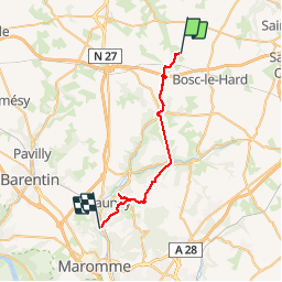
6.5 km | 7.2 km-effort
1h 44min
Yes
Trail Other activity La Crique - Rallye de Gonneville - 2005-02 - Photo
Other activity
ehalle8544

Other activity

Easy
La Crique, Normandy, Seine-Maritime, France
25 km | 29 km-effort
3h 0min
No
Trail Walking Étaimpuis - Maison cleres bollard  - Photo
Walking
andrelanglois

Walking

Very difficult
(1)
Étaimpuis, Normandy, Seine-Maritime, France
20 km | 23 km-effort
5h 17min
Yes
Trail Other activity Étaimpuis - 2012-06-21 19h53m24 - Photo
Other activity
bruno.pavie

Other activity

Very easy
Étaimpuis, Normandy, Seine-Maritime, France
1.2 km | 1.3 km-effort
1min
No


Close
My subscriptions