km vertical jarrier en circuit

lecmic
User
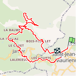

Length
12.9 km

Max alt
1619 m

Uphill gradient
1086 m
Km-Effort
27 km

Min alt
554 m

Downhill gradient
1046 m
Boucle
No
Creation date :
2019-06-21 06:06:47.096
Updated on :
2019-06-21 11:49:02.494
4h50
Difficulty : Difficult

FREE GPS app for hiking
 SityTrail
IGN / Geographical institutes
SityTrail Plus
The world is yours!
About
Trail Walking of 12.9 km to be discovered at Auvergne-Rhône-Alpes, Savoy, Saint-Jean-de-Maurienne. This trail is proposed by lecmic.
Positioning
Country:
France
Region :
Auvergne-Rhône-Alpes
Department/Province :
Savoy
Municipality :
Saint-Jean-de-Maurienne
Location:
Unknown
Start:(Dec)
Start:(UTM)
291791 ; 5017684 (32T) N.
Comments