


![Trail Walking Arzacq-Arraziguet - [30] Compostelle : de Arzacq-Arraziguet à Pomps - Photo](https://media.geolcdn.com/t/1900/400/ext.pjpeg?maxdim=2&url=https%3A%2F%2Fstatic1.geolcdn.com%2Fsiteimages%2Fupload%2Ffiles%2F1553511878bg_sport_marche.png)
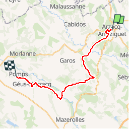
[30] Compostelle : de Arzacq-Arraziguet à Pomps

phimar_2612
User

Length
21 km

Max alt
247 m

Uphill gradient
355 m
Km-Effort
26 km

Min alt
102 m

Downhill gradient
461 m
Boucle
No
Creation date :
2019-06-23 05:30:37.586
Updated on :
2019-06-23 11:22:19.972
4h52
Difficulty : Easy

FREE GPS app for hiking
 SityTrail
IGN / Geographical institutes
SityTrail Plus
The world is yours!
About
Trail Walking of 21 km to be discovered at New Aquitaine, Pyrénées-Atlantiques, Arzacq-Arraziguet. This trail is proposed by phimar_2612.
Positioning
Country:
France
Region :
New Aquitaine
Department/Province :
Pyrénées-Atlantiques
Municipality :
Arzacq-Arraziguet
Location:
Unknown
Start:(Dec)
Start:(UTM)
709118 ; 4823540 (30T) N.
Comments