


CC_Velay_GC_30_Ostabat-Asme_St-Jean-Pied-Port_20090414

patrickdanilo
User
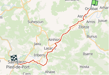

Length
23 km

Max alt
274 m

Uphill gradient
435 m
Km-Effort
28 km

Min alt
137 m

Downhill gradient
413 m
Boucle
No
Creation date :
2019-06-24 07:43:17.079
Updated on :
2022-09-19 15:01:16.969
6h00
Difficulty : Medium

FREE GPS app for hiking
 SityTrail
IGN / Geographical institutes
SityTrail Plus
The world is yours!
About
Trail Walking of 23 km to be discovered at New Aquitaine, Pyrénées-Atlantiques, Ostabat-Asme. This trail is proposed by patrickdanilo.
Description
Randonnée Marche de 23 km à découvrir à Nouvelle-Aquitaine, Pyrénées-Atlantiques, Ostabat-Asme. Cette randonnée est proposée par patrickdanilo.
Photos


Positioning
Country:
France
Region :
New Aquitaine
Department/Province :
Pyrénées-Atlantiques
Municipality :
Ostabat-Asme
Location:
Unknown
Start:(Dec)
Start:(UTM)
656442 ; 4790949 (30T) N.
Comments