


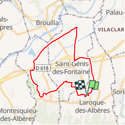
RP66 LAROQUE-ST génis-VILLELONGUE

jeff66
User

Length
15.4 km

Max alt
98 m

Uphill gradient
117 m
Km-Effort
16.9 km

Min alt
32 m

Downhill gradient
116 m
Boucle
Yes
Creation date :
2019-06-30 06:11:12.0
Updated on :
2019-06-30 15:29:12.158
--
Difficulty : Unknown
2h31
Difficulty : Unknown

FREE GPS app for hiking
 SityTrail
IGN / Geographical institutes
SityTrail Plus
The world is yours!
About
Trail Walking of 15.4 km to be discovered at Occitania, Pyrénées-Orientales, Laroque-des-Albères. This trail is proposed by jeff66.
Description
RP66 LAROQUE - ch. de la boutade - ST génis - VILLELONGUE - ch. de matemale - La grange - CBS béton - mas Roger - la flotte - ST génis - la Prade - LAROQUE - le 30.06.2019
Positioning
Country:
France
Region :
Occitania
Department/Province :
Pyrénées-Orientales
Municipality :
Laroque-des-Albères
Location:
Unknown
Start:(Dec)
Start:(UTM)
494303 ; 4708450 (31T) N.
Comments