


le claux -Marie

BIBAR
User
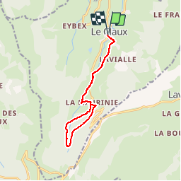

Length
12.1 km

Max alt
1183 m

Uphill gradient
226 m
Km-Effort
15.1 km

Min alt
1035 m

Downhill gradient
226 m
Boucle
Yes
Creation date :
2019-06-30 06:50:04.276
Updated on :
2019-06-30 19:19:44.715
3h11
Difficulty : Easy

FREE GPS app for hiking
 SityTrail
IGN / Geographical institutes
SityTrail Plus
The world is yours!
About
Trail Walking of 12.1 km to be discovered at Auvergne-Rhône-Alpes, Cantal, Le Claux. This trail is proposed by BIBAR.
Positioning
Country:
France
Region :
Auvergne-Rhône-Alpes
Department/Province :
Cantal
Municipality :
Le Claux
Location:
Unknown
Start:(Dec)
Start:(UTM)
476882 ; 5000684 (31T) N.
Comments