


20190702LesBaux Bédouin

Jeanclaudebic
User
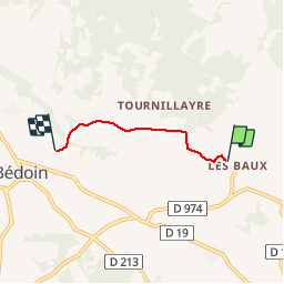

Length
2.7 km

Max alt
416 m

Uphill gradient
0 m
Km-Effort
2.9 km

Min alt
329 m

Downhill gradient
86 m
Boucle
No
Creation date :
2019-07-02 17:48:09.225
Updated on :
2019-07-02 18:18:36.689
30m
Difficulty : Very easy

FREE GPS app for hiking
 SityTrail
IGN / Geographical institutes
SityTrail Plus
The world is yours!
About
Trail Walking of 2.7 km to be discovered at Provence-Alpes-Côte d'Azur, Vaucluse, Bédoin. This trail is proposed by Jeanclaudebic.
Positioning
Country:
France
Region :
Provence-Alpes-Côte d'Azur
Department/Province :
Vaucluse
Municipality :
Bédoin
Location:
Unknown
Start:(Dec)
Start:(UTM)
677037 ; 4888170 (31T) N.
Comments