


Lucelle - Chateau Morimont

regisbodilis
User
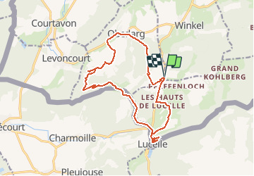

Length
16.4 km

Max alt
751 m

Uphill gradient
459 m
Km-Effort
23 km

Min alt
502 m

Downhill gradient
459 m
Boucle
Yes
Creation date :
2014-12-10 00:00:00.0
Updated on :
2014-12-10 00:00:00.0
4h00
Difficulty : Easy

FREE GPS app for hiking
 SityTrail
IGN / Geographical institutes
SityTrail Plus
The world is yours!
About
Trail Walking of 16.4 km to be discovered at Grand Est, Haut-Rhin, Winkel. This trail is proposed by regisbodilis.
Description
Lucelle-Morimont-Oberlag-Les verreries
Positioning
Country:
France
Region :
Grand Est
Department/Province :
Haut-Rhin
Municipality :
Winkel
Location:
Unknown
Start:(Dec)
Start:(UTM)
368236 ; 5255938 (32T) N.
Comments