


Ferrette - Grotte des nains

regisbodilis
User
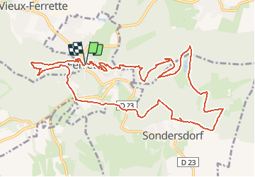

Length
13.1 km

Max alt
676 m

Uphill gradient
595 m
Km-Effort
21 km

Min alt
485 m

Downhill gradient
595 m
Boucle
Yes
Creation date :
2014-12-10 00:00:00.0
Updated on :
2014-12-10 00:00:00.0
4h00
Difficulty : Easy

FREE GPS app for hiking
 SityTrail
IGN / Geographical institutes
SityTrail Plus
The world is yours!
About
Trail Walking of 13.1 km to be discovered at Grand Est, Haut-Rhin, Ferrette. This trail is proposed by regisbodilis.
Description
Ferrette - Chateau - Grotte des nains - Bergmatten - Rossberg
Positioning
Country:
France
Region :
Grand Est
Department/Province :
Haut-Rhin
Municipality :
Ferrette
Location:
Unknown
Start:(Dec)
Start:(UTM)
373012 ; 5261475 (32T) N.
Comments
Belle randonnée en campagne bretonne