


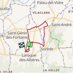
RP66 LAROQUE-DES-ALBÈRES SOREDE ST ANDRÉ

jeff66
User

Length
10.7 km

Max alt
91 m

Uphill gradient
84 m
Km-Effort
11.8 km

Min alt
32 m

Downhill gradient
82 m
Boucle
Yes
Creation date :
2019-07-05 06:11:12.0
Updated on :
2019-07-05 14:07:25.695
1h51
Difficulty : Medium

FREE GPS app for hiking
 SityTrail
IGN / Geographical institutes
SityTrail Plus
The world is yours!
About
Trail Walking of 10.7 km to be discovered at Occitania, Pyrénées-Orientales, Laroque-des-Albères. This trail is proposed by jeff66.
Description
RP66 LAROQUE-DES-ALBÈRES - ch.de Tanya - gué - SOREDE - chemins de GABARRE - ST André - piste cyclo pédestre - ST GENIS - La prade - ch. de Tanya - LAROQUE-DES-ALBÈRES - le 05.07.2019
Positioning
Country:
France
Region :
Occitania
Department/Province :
Pyrénées-Orientales
Municipality :
Laroque-des-Albères
Location:
Unknown
Start:(Dec)
Start:(UTM)
494319 ; 4708494 (31T) N.
Comments