


10173628-Lac de la Clarée

bdbedeille
User
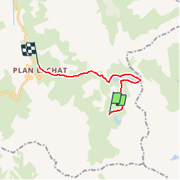

Length
7 km

Max alt
2582 m

Uphill gradient
225 m
Km-Effort
11.5 km

Min alt
1971 m

Downhill gradient
665 m
Boucle
No
Creation date :
2019-07-06 19:28:10.787
Updated on :
2019-07-06 19:28:57.723

FREE GPS app for hiking
 SityTrail
IGN / Geographical institutes
SityTrail Plus
The world is yours!
About
Trail of 7 km to be discovered at Auvergne-Rhône-Alpes, Savoy, Valloire. This trail is proposed by bdbedeille.
Positioning
Country:
France
Region :
Auvergne-Rhône-Alpes
Department/Province :
Savoy
Municipality :
Valloire
Location:
Unknown
Start:(Dec)
Start:(UTM)
300866 ; 4994183 (32T) N.
Comments