


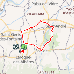
RP66 SOREDE ST ANDRÉ ST GENIS LAROQUE-DES-ALBÈRES

jeff66
User


2h17
Difficulty : Difficult

FREE GPS app for hiking
 SityTrail
IGN / Geographical institutes
SityTrail Plus
The world is yours!
About
Trail Walking of 13.1 km to be discovered at Occitania, Pyrénées-Orientales, Laroque-des-Albères. This trail is proposed by jeff66.
Description
RP66 Laroque-des-Albères - chemin de Tanya - gué - SOREDE - chemin de La GABARRE -chemin de La coscolleda - ST André - collège - piste cyclo-pédestre - ST GENIS - La prade - chemin de Tanya - Laroque-des-Albères - le 09.07.2019
Positioning
Comments