


Ranspach-St.Hubert

JCLUTT
User
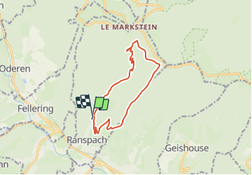

Length
11.5 km

Max alt
1096 m

Uphill gradient
632 m
Km-Effort
20 km

Min alt
470 m

Downhill gradient
627 m
Boucle
Yes
Creation date :
2019-07-09 17:24:31.606
Updated on :
2023-09-26 08:09:12.775
4h32
Difficulty : Easy

FREE GPS app for hiking
 SityTrail
IGN / Geographical institutes
SityTrail Plus
The world is yours!
About
Trail On foot of 11.5 km to be discovered at Grand Est, Haut-Rhin, Ranspach. This trail is proposed by JCLUTT.
Positioning
Country:
France
Region :
Grand Est
Department/Province :
Haut-Rhin
Municipality :
Ranspach
Location:
Unknown
Start:(Dec)
Start:(UTM)
351540 ; 5306302 (32T) N.
Comments