


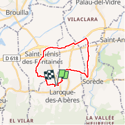
RP66 LAROQUE-ST GENIS -ST André-SOREDE

jeff66
User


1h50
Difficulty : Medium

FREE GPS app for hiking
 SityTrail
IGN / Geographical institutes
SityTrail Plus
The world is yours!
About
Trail Walking of 11.3 km to be discovered at Occitania, Pyrénées-Orientales, Laroque-des-Albères. This trail is proposed by jeff66.
Description
RP66 Laroque-des-Albères - les vernèdes - chemin de la boutade - ST GENIS - le Riberal - église - poste - ch. des moines - La Prade - piste cyclo pédestre - centre commercial - villeclare - SOREDE - ch. des GABARRE - gué - route de Tanya - Laroque-des-Albères - le 12-07-19
Positioning
Comments