


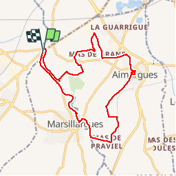
RP34+30 LUNEL - AIMARGUES - MARSILLARGUES - LUNEL

jeff66
User


3h37
Difficulty : Difficult

FREE GPS app for hiking
 SityTrail
IGN / Geographical institutes
SityTrail Plus
The world is yours!
About
Trail Walking of 19.1 km to be discovered at Occitania, Hérault, Lunel. This trail is proposed by jeff66.
Description
RP34 30 LUNEL - pont de Lunel - berge du vidourle - mas de l’aire, rieutord et ST Rémy - AIMARGUES - centre ville - La jouberte - le creux de blanc - plan de praviel - château de Teillan - MARSILLARGUES - pont Boulet - berges du vidourle - Langlon - le moulin Bernard - pont de LUNEL - le 13.07.19
Positioning
Comments