


le piolit version2

gerardmicheline
User
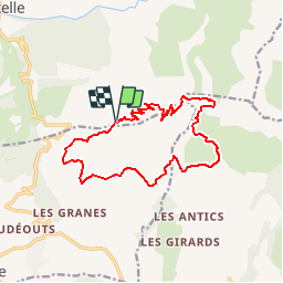

Length
15.6 km

Max alt
2434 m

Uphill gradient
952 m
Km-Effort
28 km

Min alt
1566 m

Downhill gradient
949 m
Boucle
Yes
Creation date :
2019-07-14 13:56:39.172
Updated on :
2019-07-14 14:03:17.195
5h42
Difficulty : Very difficult

FREE GPS app for hiking
 SityTrail
IGN / Geographical institutes
SityTrail Plus
The world is yours!
About
Trail Walking of 15.6 km to be discovered at Provence-Alpes-Côte d'Azur, Hautes-Alpes, Ancelle. This trail is proposed by gerardmicheline.
Positioning
Country:
France
Region :
Provence-Alpes-Côte d'Azur
Department/Province :
Hautes-Alpes
Municipality :
Ancelle
Location:
Unknown
Start:(Dec)
Start:(UTM)
281431 ; 4941973 (32T) N.
Comments