


Refuge Frederico Chabot

LaurentGILG
User

Length
5.8 km

Max alt
2703 m

Uphill gradient
819 m
Km-Effort
14 km

Min alt
1880 m

Downhill gradient
2 m
Boucle
No
Creation date :
2019-07-11 08:53:16.28
Updated on :
2019-07-17 03:56:25.114
4h08
Difficulty : Very difficult

FREE GPS app for hiking
 SityTrail
IGN / Geographical institutes
SityTrail Plus
The world is yours!
About
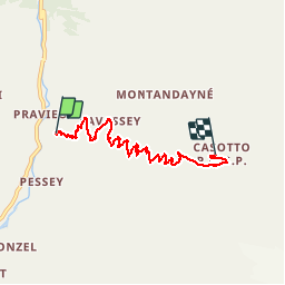
Trail Walking of 5.8 km to be discovered at Aosta Valley, Unknown, Valsavarenche. This trail is proposed by LaurentGILG.
Positioning
Country:
Italy
Region :
Aosta Valley
Department/Province :
Unknown
Municipality :
Valsavarenche
Location:
Unknown
Start:(Dec)
Start:(UTM)
360591 ; 5044781 (32T) N.
Comments