


Trou de l'aigle

soca
User
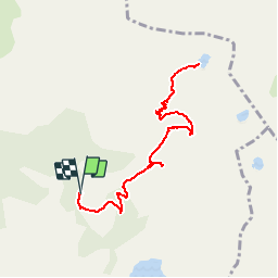

Length
10.5 km

Max alt
2686 m

Uphill gradient
597 m
Km-Effort
18.5 km

Min alt
2108 m

Downhill gradient
593 m
Boucle
Yes
Creation date :
2019-07-17 21:28:59.788
Updated on :
2019-07-17 21:29:44.423
3h45
Difficulty : Difficult

FREE GPS app for hiking
 SityTrail
IGN / Geographical institutes
SityTrail Plus
The world is yours!
About
Trail Walking of 10.5 km to be discovered at Provence-Alpes-Côte d'Azur, Alpes-de-Haute-Provence, Allos. This trail is proposed by soca.
Positioning
Country:
France
Region :
Provence-Alpes-Côte d'Azur
Department/Province :
Alpes-de-Haute-Provence
Municipality :
Allos
Location:
Unknown
Start:(Dec)
Start:(UTM)
316190 ; 4901697 (32T) N.
Comments