le champ de la bataille

Liebeaux
User
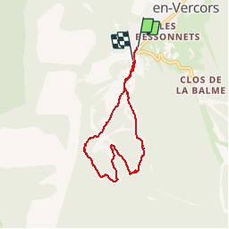

Length
6.9 km

Max alt
1261 m

Uphill gradient
154 m
Km-Effort
8.9 km

Min alt
1138 m

Downhill gradient
140 m
Boucle
No
Creation date :
2019-07-18 09:58:23.407
Updated on :
2019-07-18 16:28:16.248
2h40
Difficulty : Very easy

FREE GPS app for hiking
 SityTrail
IGN / Geographical institutes
SityTrail Plus
The world is yours!
About
Trail Walking of 6.9 km to be discovered at Auvergne-Rhône-Alpes, Isère, Corrençon-en-Vercors. This trail is proposed by Liebeaux.
Positioning
Country:
France
Region :
Auvergne-Rhône-Alpes
Department/Province :
Isère
Municipality :
Corrençon-en-Vercors
Location:
Unknown
Start:(Dec)
Start:(UTM)
698382 ; 4988835 (31T) N.
Comments