Trail Walking Allos - Tête de Sestriere - Source du verdon - Photo

Tête de Sestriere - Source du verdon

© OpenStreetMap contributors
Length
Length
9.5 km
Max alt
Max alt
2560 m
Uphill gradient
Uphill gradient
698 m
Km-Effort
Km-Effort  
18.8 km
Min alt
Min alt
1851 m
Downhill gradient
Downhill gradient
700 m
Boucle
Boucle
Yes
Creation date :
2014-12-10 00:00:00.0
Updated on :
2014-12-10 00:00:00.0

(0 Reviews)

Walking
Walking
3h38
Difficulty : Medium

Scan this QR Code to open this trail in the SityTrail application

FREE GPS app for hiking

Logo SityTrail SityTrail

IGN / Geographical institutes

Download SityTrail from the App Store Download SityTrail from Google Play

Logo SityTrail SityTrail Plus

The world is yours!

Download SityTrail from the App Store Download SityTrail from Google Play Download SityTrail on Huawei AppGallery

About

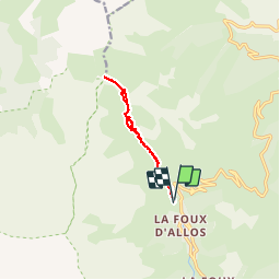
Trail Walking of 9.5 km to be discovered at Provence-Alpes-Côte d'Azur, Alpes-de-Haute-Provence, Allos. This trail is proposed by perrinfabrice.

Description

Départ arrivée du téléski "Chauvets", montée en direction de la cabane de berger, suivre le tracé jusqu'au sommet du col de Sestriere. À partir du col suivre l'arête jusqu'au sommet "Tête de Sestriere". Magnifique panorama à 360 degré.  Randonnée réalisable en famille en 4 heures, en tenant compte des poses repos, ravitaillement et observation. Réalisable en 3 heures a un rythme sportif sans être pour autant un grand sportif.

Elevation profile

Positioning

Country:
France
Region :
Provence-Alpes-Côte d'Azur
Department/Province :
Alpes-de-Haute-Provence
Municipality :
Allos
Location:
Unknown
Start:(Dec)
Start:(UTM)
305927 ; 4907595 (32T) N.


Close
My subscriptions