


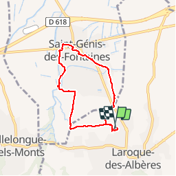
M66 LAROQUE-DES-ALBÈRES ST GENIS

jeff66
User

Length
6.4 km

Max alt
91 m

Uphill gradient
47 m
Km-Effort
7.1 km

Min alt
51 m

Downhill gradient
47 m
Boucle
Yes
Creation date :
2019-07-22 07:19:28.0
Updated on :
2019-07-22 11:05:03.928
1h08
Difficulty : Medium

FREE GPS app for hiking
 SityTrail
IGN / Geographical institutes
SityTrail Plus
The world is yours!
About
Trail Walking of 6.4 km to be discovered at Occitania, Pyrénées-Orientales, Laroque-des-Albères. This trail is proposed by jeff66.
Description
M66 Laroque-des-Albères - ST GENIS - Laroque-des-Albères - le 22.07.2019
Positioning
Country:
France
Region :
Occitania
Department/Province :
Pyrénées-Orientales
Municipality :
Laroque-des-Albères
Location:
Unknown
Start:(Dec)
Start:(UTM)
494254 ; 4708438 (31T) N.
Comments