Trail Sled dogs Chamonix-Mont-Blanc - chx plan praz. brevet. bellachat. chx - Photo

chx plan praz. brevet. bellachat. chx

 jeff2
jeff2

User

© OpenStreetMap contributors
Length
Length
13.3 km
Max alt
Max alt
2502 m
Uphill gradient
Uphill gradient
1513 m
Km-Effort
Km-Effort  
32 km
Min alt
Min alt
1048 m
Downhill gradient
Downhill gradient
1172 m
Boucle
Boucle
No
Creation date :
2019-07-23 06:19:11.926
Updated on :
2019-07-23 17:04:59.345

(0 Reviews)

Sled dogs
Sled dogs
6h37
Difficulty : Difficult

Scan this QR Code to open this trail in the SityTrail application

FREE GPS app for hiking

Logo SityTrail SityTrail

IGN / Geographical institutes

Download SityTrail from the App Store Download SityTrail from Google Play

Logo SityTrail SityTrail World

The world is yours!

Download SityTrail from the App Store Download SityTrail from Google Play Download SityTrail on Huawei AppGallery

About

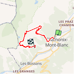
Trail Sled dogs of 13.3 km to be discovered at Auvergne-Rhône-Alpes, Upper Savoy, Chamonix-Mont-Blanc. This trail is proposed by jeff2.

Description

Remise en jambe

Elevation profile

Photos

Positioning

Country:
France
Region :
Auvergne-Rhône-Alpes
Department/Province :
Upper Savoy
Municipality :
Chamonix-Mont-Blanc
Location:
Unknown
Start:(UTM)
334846 ; 5088163 (32T) N.

Trails nearby

Trail Running Chamonix-Mont-Blanc - The North Face© Ultra Trail du Mont-Blanc© UTMB 2008 - Photo
Running
tracegps

Running

Very difficult
(2)
Chamonix-Mont-Blanc, Auvergne-Rhône-Alpes, Upper Savoy, France
160 km | 288 km-effort
46h 0min
Yes
Trail Walking Chamonix-Mont-Blanc - Circuit de la Mer de Glace - Chamonix Mont Blanc - Photo
Walking
tracegps

Walking

Difficult
(2)
Chamonix-Mont-Blanc, Auvergne-Rhône-Alpes, Upper Savoy, France
13.3 km | 24 km-effort
5h 30min
Yes
Trail Walking Chamonix-Mont-Blanc - Glacier des Bossons Les Houches Chamonix - Photo
Walking
tracegps

Walking

Difficult
(2)
Chamonix-Mont-Blanc, Auvergne-Rhône-Alpes, Upper Savoy, France
13.1 km | 28 km-effort
5h 0min
Yes
Trail Running Chamonix-Mont-Blanc - Hôtel Arveyron au Chalet de la Floria - Photo
Running
Albust

Running

Medium
(1)
Chamonix-Mont-Blanc, Auvergne-Rhône-Alpes, Upper Savoy, France
10.4 km | 15.5 km-effort
1h 28min
Yes
Trail Walking Chamonix-Mont-Blanc - La cascade du dard - Photo
Walking
GUIDE
pascalou73

Walking

Medium
Chamonix-Mont-Blanc, Auvergne-Rhône-Alpes, Upper Savoy, France
8.2 km | 13.6 km-effort
2h 0min
Yes
Trail Walking Chamonix-Mont-Blanc - Le lac bleus - Photo
Walking
GUIDE
pascalou73

Walking

Medium
Chamonix-Mont-Blanc, Auvergne-Rhône-Alpes, Upper Savoy, France
17.1 km | 35 km-effort
6h 57min
Yes
Trail Mountain bike Chamonix-Mont-Blanc - vtt à Chamonix - Photo
Mountain bike
GUIDE
pascalou73

Mountain bike

Medium
Chamonix-Mont-Blanc, Auvergne-Rhône-Alpes, Upper Savoy, France
15.9 km | 19.5 km-effort
1h 30min
No
Trail Walking Chamonix-Mont-Blanc - aller/retour La Floria Chamonix  - Photo
Walking
jeff2

Walking

Easy
Chamonix-Mont-Blanc, Auvergne-Rhône-Alpes, Upper Savoy, France
5.6 km | 9.9 km-effort
1h 22min
Yes
Trail Walking Les Houches - boucle aiguillette des houches ,refuge bel-lachat - Photo
Walking
carton-fils@orange.fr

Walking

Very difficult
Les Houches, Auvergne-Rhône-Alpes, Upper Savoy, France
10.4 km | 24 km-effort
2h 49min
Yes


Close
My subscriptions