


2407Miniere

maxEA65
User
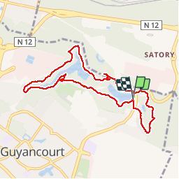

Length
8 km

Max alt
164 m

Uphill gradient
148 m
Km-Effort
10 km

Min alt
116 m

Downhill gradient
149 m
Boucle
Yes
Creation date :
2019-07-24 05:36:24.086
Updated on :
2019-07-24 07:11:14.512
1h34
Difficulty : Very easy

FREE GPS app for hiking
 SityTrail
IGN / Geographical institutes
SityTrail Plus
The world is yours!
About
Trail Walking of 8 km to be discovered at Ile-de-France, Yvelines, Guyancourt. This trail is proposed by maxEA65.
Positioning
Country:
France
Region :
Ile-de-France
Department/Province :
Yvelines
Municipality :
Guyancourt
Location:
Unknown
Start:(Dec)
Start:(UTM)
433539 ; 5403329 (31U) N.
Comments