Trail Walking Carlat - x - Photo
 cz6915
cz6915

User

© OpenStreetMap contributors
Length
Length
13.4 km
Max alt
Max alt
875 m
Uphill gradient
Uphill gradient
374 m
Km-Effort
Km-Effort  
18.5 km
Min alt
Min alt
742 m
Downhill gradient
Downhill gradient
382 m
Boucle
Boucle
No
Creation date :
2019-07-24 07:00:34.555
Updated on :
2019-07-25 09:17:03.837

(1 Reviews)

Walking
Walking
7h39
Difficulty : Very easy

Scan this QR Code to open this trail in the SityTrail application

FREE GPS app for hiking

Logo SityTrail SityTrail

IGN / Geographical institutes

Download SityTrail from the App Store Download SityTrail from Google Play

Logo SityTrail SityTrail World

The world is yours!

Download SityTrail from the App Store Download SityTrail from Google Play Download SityTrail on Huawei AppGallery

About

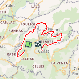
Trail Walking of 13.4 km to be discovered at Auvergne-Rhône-Alpes, Cantal, Carlat. This trail is proposed by cz6915.

Description

randonnée  le rocher 0

Elevation profile

Positioning

Country:
France
Region :
Auvergne-Rhône-Alpes
Department/Province :
Cantal
Municipality :
Carlat
Location:
Unknown
Start:(UTM)
464169 ; 4970724 (31T) N.

Comments

Please log in to post a review or rate the element


Fait en vtt. magnifique mais des passages compliqués 😁


Trails nearby

Trail Walking Saint-Étienne-de-Carlat - La croix des Lucs - Photo
Walking
neleda

Walking

Medium
Saint-Étienne-de-Carlat, Auvergne-Rhône-Alpes, Cantal, France
7.8 km | 10.5 km-effort
2h 12min
Yes
Trail Walking Vézac - Ce sac-Polminhac - Photo
Walking
Jean-Marie Bousquet

Walking

Difficult
Vézac, Auvergne-Rhône-Alpes, Cantal, France
12.5 km | 17.5 km-effort
3h 1min
No
Trail Road bike Vézac - Mur de Barrez - Photo
Road bike
Jean-Marie Bousquet

Road bike

Medium
Vézac, Auvergne-Rhône-Alpes, Cantal, France
57 km | 73 km-effort
3h 17min
Yes
Trail Walking Vézac - vezac - Photo
Walking
17071969

Walking

Very easy
Vézac, Auvergne-Rhône-Alpes, Cantal, France
3 km | 3.7 km-effort
40min
No
Trail Walking Carlat - Tour de Puybasset - Photo
Walking
alainlissac

Walking

Carlat, Auvergne-Rhône-Alpes, Cantal, France
14.7 km | 21 km-effort
4h 5min
Yes
Trail Nordic walking Labrousse - Labrousse - Photo
Nordic walking
nikouston15

Nordic walking

Difficult
Labrousse, Auvergne-Rhône-Alpes, Cantal, France
7 km | 10.1 km-effort
1h 33min
Yes
Trail Walking Vézac - espinetcouffin lentat le fouette  - Photo
Walking
vertut

Walking

Difficult
Vézac, Auvergne-Rhône-Alpes, Cantal, France
11.4 km | 14.9 km-effort
3h 10min
No
Trail Cycle Giou-de-Mamou - puy  mary - Photo
Cycle
denel

Cycle

Medium
Giou-de-Mamou, Auvergne-Rhône-Alpes, Cantal, France
87 km | 115 km-effort
6h 27min
Yes
Trail Walking Carlat - plateau par boviduc - Photo
Walking
cz6915

Walking

Easy
Carlat, Auvergne-Rhône-Alpes, Cantal, France
3.7 km | 5.3 km-effort
1h 26min
Yes


Close
My subscriptions