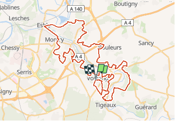
16.1 km | 19.5 km-effort
Boucle VTT Voulangis - Esbly - Quincy
tracegps
User
Length
54 km
Max alt
138 m
Uphill gradient
1072 m
Km-Effort
68 km
Min alt
43 m
Downhill gradient
1075 m
Boucle
Yes
Creation date :
2014-12-10 00:00:00.0
Updated on :
2014-12-10 00:00:00.0
4h19
Difficulty : Difficult
FREE GPS app for hiking
About
Trail Mountain bike of 54 km to be discovered at Ile-de-France, Seine-et-Marne, Voulangis. This trail is proposed by tracegps.
Description
Belle boucle avec quelques bonnes côtes. Rando à éviter par temps trop gras.
Positioning
Country:
France
Region :
Ile-de-France
Department/Province :
Seine-et-Marne
Municipality :
Voulangis
Location:
Unknown
Start:(Dec)
Start:(UTM)
491762 ; 5410755 (31U) N.
Comments
Trails nearby
Crécy la Chapelle Parcours normal
Walking
Easy
(1)
Crécy-la-Chapelle,
Ile-de-France,
Seine-et-Marne,
France
4h 18min
Yes
Crécy la chapelle
Walking
Easy
(2)
Crécy-la-Chapelle,
Ile-de-France,
Seine-et-Marne,
France
19.7 km | 24 km-effort
5h 12min
Yes
Crécy la Chapelle
Walking
Medium
(1)
Crécy-la-Chapelle,
Ile-de-France,
Seine-et-Marne,
France
16.4 km | 20 km-effort
4h 23min
Yes
Autour de Tigeaux
Walking
Medium
(2)
Crécy-la-Chapelle,
Ile-de-France,
Seine-et-Marne,
France
13.2 km | 16.5 km-effort
2h 37min
Yes
Boucle 28 km autour de Crecy la Chapelle - Guérard - Voulangis - Tigeaux
Walking
Medium
Crécy-la-Chapelle,
Ile-de-France,
Seine-et-Marne,
France
28 km | 35 km-effort
5h 46min
Yes
Tigeaux
Walking
Medium
(1)
Tigeaux,
Ile-de-France,
Seine-et-Marne,
France
19.1 km | 24 km-effort
5h 24min
Yes
Les coteaux du Grand Morin
Walking
Medium
Crécy-la-Chapelle,
Ile-de-France,
Seine-et-Marne,
France
11.8 km | 14.3 km-effort
3h 6min
Yes
Bouleurs
Walking
Easy
Bouleurs,
Ile-de-France,
Seine-et-Marne,
France
16.4 km | 18.6 km-effort
4h 5min
Yes
Le nord de la Vallée du grand Morin
Cycle
Medium
Saint-Germain-sur-Morin,
Ile-de-France,
Seine-et-Marne,
France
53 km | 63 km-effort
3h 10min
Yes