Trail Mountain bike Sainte-Orse - De Sainte Orse au Verdoyant - Photo

De Sainte Orse au Verdoyant

 tracegps
tracegps

User

© OpenStreetMap contributors
Length
Length
32 km
Max alt
Max alt
282 m
Uphill gradient
Uphill gradient
593 m
Km-Effort
Km-Effort  
40 km
Min alt
Min alt
148 m
Downhill gradient
Downhill gradient
622 m
Boucle
Boucle
No
Creation date :
2014-12-10 00:00:00.0
Updated on :
2014-12-10 00:00:00.0

(0 Reviews)

Mountain bike
Mountain bike
3h00
Difficulty : Difficult

Scan this QR Code to open this trail in the SityTrail application

FREE GPS app for hiking

Logo SityTrail SityTrail

IGN / Geographical institutes

Download SityTrail from the App Store Download SityTrail from Google Play

Logo SityTrail SityTrail World

The world is yours!

Download SityTrail from the App Store Download SityTrail from Google Play Download SityTrail on Huawei AppGallery

About

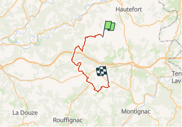
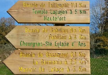
Trail Mountain bike of 32 km to be discovered at New Aquitaine, Dordogne, Sainte-Orse. This trail is proposed by tracegps.

Description

Retour au camping le VERDOYANT après pique-nique au lavoir de Sainte Orse. A l'arrivée au camping, Christophe se fera un plaisir de vous servir une Ch'ti (A boire avec modération).

Elevation profile

Photos

Positioning

Country:
France
Region :
New Aquitaine
Department/Province :
Dordogne
Municipality :
Sainte-Orse
Location:
Unknown
Start:(UTM)
348825 ; 5007526 (31T) N.

Trails nearby

Trail Walking Sainte-Eulalie-d'Ans - Ste Eulalie d'Ans bcle Ste Eulalie - Photo
Walking
YV24

Walking

Easy
(1)
Sainte-Eulalie-d'Ans, New Aquitaine, Dordogne, France
9.7 km | 11.8 km-effort
2h 32min
Yes
Trail Walking Sainte-Orse - Boucle Taille petit variante  - Photo
Walking
NICOLEROBERT

Walking

Medium
Sainte-Orse, New Aquitaine, Dordogne, France
12 km | 15.3 km-effort
3h 5min
Yes
Trail Walking Gabillou - boucle des murs en pierres sèches  - Photo
Walking
dmortier

Walking

Medium
Gabillou, New Aquitaine, Dordogne, France
8.8 km | 10.8 km-effort
2h 34min
Yes
Trail Walking Granges-d'Ans - Paysage et nature depuis Granges-d’Ans - Photo
Walking
houbart

Walking

Difficult
Granges-d'Ans, New Aquitaine, Dordogne, France
11.8 km | 15 km-effort
3h 24min
Yes
Trail Walking Sainte-Orse - Ste Orse Taillepetit 13km - Photo
Walking
YV24

Walking

Easy
Sainte-Orse, New Aquitaine, Dordogne, France
12.1 km | 15.2 km-effort
3h 20min
Yes
Trail Walking Sainte-Orse - St Orse Boucle de Gabillou - Photo
Walking
swp648

Walking

Easy
Sainte-Orse, New Aquitaine, Dordogne, France
11.1 km | 13.4 km-effort
2h 38min
Yes
Trail On foot Chourgnac - chourgnac d'ans - Photo
On foot
Patricew

On foot

Easy
Chourgnac, New Aquitaine, Dordogne, France
11.1 km | 13.5 km-effort
3h 3min
Yes
Trail Walking Ajat - Beauzens Rozas La Rolfie 12km - Photo
Walking
YV24

Walking

Easy
Ajat, New Aquitaine, Dordogne, France
11.7 km | 14.3 km-effort
2h 54min
Yes
Trail Walking Gabillou - Boucle des murs en pierres séches Gabillou - Photo
Walking
swp648

Walking

Medium
Gabillou, New Aquitaine, Dordogne, France
8.3 km | 10.4 km-effort
2h 22min
Yes


Close
My subscriptions