![](/images/other/stat-length.png)
![Trail Walking Ottange - Réserve Naturelle Ellergronn - Ottange - Photo](https://media.geolcdn.com/t/1900/400/ext.pjpeg?maxdim=2&url=https%3A%2F%2Fservices.sitytrail.com%2FGeolivesWS%2FDownloadMedia.ashx%3FTrailID%3D215102%26Media%3D15684_5.jpg)
Réserve Naturelle Ellergronn - Ottange
tracegps
User
![Length](/images/other/stat-length.png)
Length
11.6 km
![Max alt](https://static1.geolcdn.com/siteimages/upload/files/1508320355ic_sort_altitude_max_24dp.png)
Max alt
444 m
![Uphill gradient](https://static1.geolcdn.com/siteimages/upload/files/1508320355ic_sort_den_pos_24dp.png)
Uphill gradient
269 m
![Km-Effort](/images/other/stat-length.png)
Km-Effort
15.2 km
![Min alt](https://static1.geolcdn.com/siteimages/upload/files/1508320355ic_sort_altitude_min_24dp.png)
Min alt
313 m
![Downhill gradient](https://static1.geolcdn.com/siteimages/upload/files/1508320355ic_sort_den_neg_24dp.png)
Downhill gradient
278 m
![Boucle](https://static1.geolcdn.com/siteimages/upload/files/16400158638029165_repeat_loop_refresh_sync_direction_icon.png)
Boucle
Yes
Creation date :
2014-12-10 00:00:00.0
Updated on :
2014-12-10 00:00:00.0
![Walking](https://static1.geolcdn.com/sitytour/trail-icons/101.png)
2h30
Difficulty : Medium
![Scan this QR Code to open this trail in the SityTrail application](https://capi.geolives.com/qq0zvz2zws4bq2lad0pu/sitytour/trails/215102/qr.png?size=200)
FREE GPS app for hiking
About
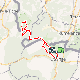
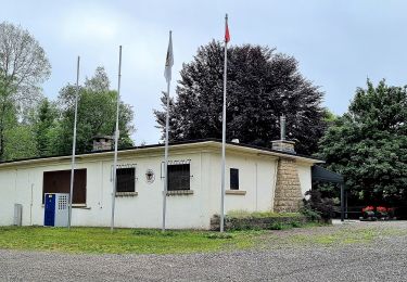
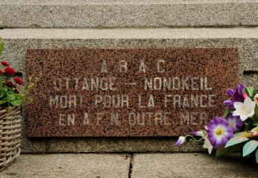
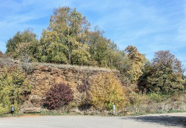
Trail Walking of 11.6 km to be discovered at Grand Est, Moselle, Ottange. This trail is proposed by tracegps.
Description
Départ de la place principale. Joli parcours permettant d'apprécier le bois d'Ottange et la réserve naturelle luxembourgeoise Ellergronn. Saisons conseillées pour le faire : printemps, été. Attention de prévoir de l'eau à boire..
Positioning
Country:
France
Region :
Grand Est
Department/Province :
Moselle
Municipality :
Ottange
Location:
Unknown
Start:(Dec)
Start:(UTM)
283765 ; 5481082 (32U) N.
Comments
Trails nearby
![Trail On foot Esch-sur-Alzette - Sentier Pierre Wiess - Photo](https://media.geolcdn.com/t/375/260/ext.jpg?maxdim=2&url=https%3A%2F%2Fmedia.geolcdn.com%2Ff%2Ffb7503a0-8edc-4589-a05b-6ac952d1b3b6.jpeg)
![On foot On foot](https://static1.geolcdn.com/sitytour/trail-icons/100.png)
Sentier Pierre Wiess
On foot
Easy
Esch-sur-Alzette,
Unknown,
Canton Esch-sur-Alzette,
Luxembourg
![](/images/other/stat-length.png)
3.9 km | 5.4 km-effort
1h 14min
![](https://static1.geolcdn.com/siteimages/upload/files/16400158638029165_repeat_loop_refresh_sync_direction_icon.png)
No
![Trail On foot Esch-sur-Alzette - Auto-Pédestre Esch-sur-Alzette - Photo](https://media.geolcdn.com/t/375/260/ext.jpg?maxdim=2&url=https%3A%2F%2Fmedia.geolcdn.com%2Ff%2Fb5c02b78-1f2a-4286-8a45-2a22bbfe4d56.jpeg)
![On foot On foot](https://static1.geolcdn.com/sitytour/trail-icons/100.png)
Auto-Pédestre Esch-sur-Alzette
On foot
Easy
Esch-sur-Alzette,
Unknown,
Canton Esch-sur-Alzette,
Luxembourg
![](/images/other/stat-length.png)
7.2 km | 9.8 km-effort
2h 13min
![](https://static1.geolcdn.com/siteimages/upload/files/16400158638029165_repeat_loop_refresh_sync_direction_icon.png)
Yes
![Trail On foot Kayl - Auto-Pédestre Kayl - Photo](https://media.geolcdn.com/t/375/260/ext.jpg?maxdim=2&url=https%3A%2F%2Fmedia.geolcdn.com%2Ff%2F05634cbd-69a7-4685-a005-dc48af1d3e5c.jpeg)
![On foot On foot](https://static1.geolcdn.com/sitytour/trail-icons/100.png)
Auto-Pédestre Kayl
On foot
Easy
Kayl,
Unknown,
Canton Esch-sur-Alzette,
Luxembourg
![](/images/other/stat-length.png)
5.9 km | 7.6 km-effort
1h 43min
![](https://static1.geolcdn.com/siteimages/upload/files/16400158638029165_repeat_loop_refresh_sync_direction_icon.png)
Yes
![Trail On foot Dudelange - Auto-Pédestre Dudelange 2 - Photo](https://media.geolcdn.com/t/375/260/ext.jpg?maxdim=2&url=https%3A%2F%2Fmedia.geolcdn.com%2Ff%2Faf1bad0c-3221-4446-bdc1-63f6fbf66e3d.jpeg)
![On foot On foot](https://static1.geolcdn.com/sitytour/trail-icons/100.png)
Auto-Pédestre Dudelange 2
On foot
Easy
Dudelange,
Unknown,
Canton Esch-sur-Alzette,
Luxembourg
![](/images/other/stat-length.png)
5.8 km | 7.5 km-effort
1h 42min
![](https://static1.geolcdn.com/siteimages/upload/files/16400158638029165_repeat_loop_refresh_sync_direction_icon.png)
No
![Trail Mountain bike Audun-le-Tiche - la randodunoise 2010 - Photo](https://media.geolcdn.com/t/375/260/ext.jpg?maxdim=2&url=https%3A%2F%2Fstatic1.geolcdn.com%2Fsiteimages%2Fupload%2Ffiles%2F1524743154velo.jpg)
![Mountain bike Mountain bike](https://static1.geolcdn.com/sitytour/trail-icons/202.png)
la randodunoise 2010
Mountain bike
Very easy
(1)
Audun-le-Tiche,
Grand Est,
Moselle,
France
![](/images/other/stat-length.png)
38 km | 48 km-effort
Unknown
![](https://static1.geolcdn.com/siteimages/upload/files/16400158638029165_repeat_loop_refresh_sync_direction_icon.png)
No
![Trail On foot Ottange - Boucle d'Ottange - Photo](https://media.geolcdn.com/t/375/260/ext.jpg?maxdim=2&url=https%3A%2F%2Fmedia.geolcdn.com%2Ff%2F4f81de2e-9288-4ceb-9209-2e12554d6d66.jpeg)
![On foot On foot](https://static1.geolcdn.com/sitytour/trail-icons/100.png)
Boucle d'Ottange
On foot
Easy
Ottange,
Grand Est,
Moselle,
France
![](/images/other/stat-length.png)
4.1 km | 5.5 km-effort
1h 14min
![](https://static1.geolcdn.com/siteimages/upload/files/16400158638029165_repeat_loop_refresh_sync_direction_icon.png)
Yes
![Trail On foot Ottange - Ottange Circuit Schmettebusch - Photo](https://media.geolcdn.com/t/375/260/ext.jpg?maxdim=2&url=https%3A%2F%2Fmedia.geolcdn.com%2Ff%2Fe03ec25f-1ced-4014-8b11-d9cfd2f098ff.jpeg)
![On foot On foot](https://static1.geolcdn.com/sitytour/trail-icons/100.png)
Ottange Circuit Schmettebusch
On foot
Easy
Ottange,
Grand Est,
Moselle,
France
![](/images/other/stat-length.png)
5.7 km | 7.9 km-effort
1h 47min
![](https://static1.geolcdn.com/siteimages/upload/files/16400158638029165_repeat_loop_refresh_sync_direction_icon.png)
No
![Trail On foot Volmerange-les-Mines - Promenade Transfrontalière - Photo](https://media.geolcdn.com/t/375/260/ext.jpg?maxdim=2&url=https%3A%2F%2Fmedia.geolcdn.com%2Ff%2Fd2239583-1f94-4d90-95bb-22cf9acd8889.jpeg)
![On foot On foot](https://static1.geolcdn.com/sitytour/trail-icons/100.png)
Promenade Transfrontalière
On foot
Easy
Volmerange-les-Mines,
Grand Est,
Moselle,
France
![](/images/other/stat-length.png)
9.9 km | 13.4 km-effort
3h 2min
![](https://static1.geolcdn.com/siteimages/upload/files/16400158638029165_repeat_loop_refresh_sync_direction_icon.png)
Yes
![Trail On foot Volmerange-les-Mines - Club Vosgiens Sentier de la Minette - Volmerange - Dudelange - Photo](https://media.geolcdn.com/t/375/260/ext.jpg?maxdim=2&url=https%3A%2F%2Fmedia.geolcdn.com%2Ff%2Fec7e514b-60dc-406a-a533-2ed713e164f9.jpeg)
![On foot On foot](https://static1.geolcdn.com/sitytour/trail-icons/100.png)
Club Vosgiens Sentier de la Minette - Volmerange - Dudelange
On foot
Easy
Volmerange-les-Mines,
Grand Est,
Moselle,
France
![](/images/other/stat-length.png)
9.4 km | 12.2 km-effort
2h 45min
![](https://static1.geolcdn.com/siteimages/upload/files/16400158638029165_repeat_loop_refresh_sync_direction_icon.png)
Yes