


celera

gillesmanfredi
User
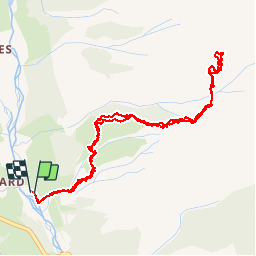

Length
6 km

Max alt
2236 m

Uphill gradient
926 m
Km-Effort
18.3 km

Min alt
1293 m

Downhill gradient
924 m
Boucle
Yes
Creation date :
2019-07-20 05:48:02.756
Updated on :
2019-07-27 10:20:01.891
12h54
Difficulty : Very easy

FREE GPS app for hiking
 SityTrail
IGN / Geographical institutes
SityTrail Plus
The world is yours!
About
Trail Climbing of 6 km to be discovered at Provence-Alpes-Côte d'Azur, Hautes-Alpes, Champoléon. This trail is proposed by gillesmanfredi.
Positioning
Country:
France
Region :
Provence-Alpes-Côte d'Azur
Department/Province :
Hautes-Alpes
Municipality :
Champoléon
Location:
Unknown
Start:(Dec)
Start:(UTM)
282470 ; 4956513 (32T) N.
Comments