Trail Mountain bike Ferrières - Forêt de Creuse - Ferrières - Photo

Forêt de Creuse - Ferrières

 tracegps
tracegps

User

© OpenStreetMap contributors
Length
Length
29 km
Max alt
Max alt
133 m
Uphill gradient
Uphill gradient
420 m
Km-Effort
Km-Effort  
35 km
Min alt
Min alt
48 m
Downhill gradient
Downhill gradient
420 m
Boucle
Boucle
Yes
Creation date :
2014-12-10 00:00:00.0
Updated on :
2014-12-10 00:00:00.0

(0 Reviews)

Mountain bike
Mountain bike
2h00
Difficulty : Medium

Scan this QR Code to open this trail in the SityTrail application

FREE GPS app for hiking

Logo SityTrail SityTrail

IGN / Geographical institutes

Download SityTrail from the App Store Download SityTrail from Google Play

Logo SityTrail SityTrail World

The world is yours!

Download SityTrail from the App Store Download SityTrail from Google Play Download SityTrail on Huawei AppGallery

About

Trail Mountain bike of 29 km to be discovered at Hauts-de-France, Somme, Ferrières. This trail is proposed by tracegps.

Description

Balade en passant par 2 vallées jusqu'au bois de Creuse. Passage par GR123.

Elevation profile

Photos

Positioning

Country:
France
Region :
Hauts-de-France
Department/Province :
Somme
Municipality :
Ferrières
Location:
Unknown
Start:(Dec)
Start:(UTM)
441124 ; 5526816 (31U) N.

Trails nearby

Trail Walking Saleux - Circuit des monts de Saleux - Photo
Walking
tracegps

Walking

Medium
Saleux, Hauts-de-France, Somme, France
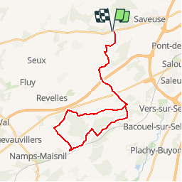
8.4 km | 9.8 km-effort
2h 4min
Yes
Trail Walking Ferrières - FERRIERES - Photo
Walking
jpblimond

Walking

Medium
Ferrières, Hauts-de-France, Somme, France
18.8 km | 21 km-effort
4h 40min
Yes
Trail Walking Ailly-sur-Somme - Circuit de la forêt d'Ailly  -  Ailly-sur-Somme - Photo
Walking
tracegps

Walking

Medium
(1)
Ailly-sur-Somme, Hauts-de-France, Somme, France
13 km | 14.9 km-effort
3h 15min
Yes
Trail Quad Dreuil-lès-Amiens - Amiens vers poix - Photo
Quad
davebon

Quad

Dreuil-lès-Amiens, Hauts-de-France, Somme, France
23 km | 27 km-effort
45min
No
Trail Walking Ailly-sur-Somme - Ailly sur Noyé.  - Photo
Walking
pat800

Walking

Easy
Ailly-sur-Somme, Hauts-de-France, Somme, France
11.6 km | 14.3 km-effort
2h 32min
Yes
Trail Other activity Saveuse - fremontiers - Photo
Other activity
dedehenry

Other activity

Very easy
Saveuse, Hauts-de-France, Somme, France
92 km | 107 km-effort
40h 56min
No
Trail Cycle Dreuil-lès-Amiens - canal amiens - Photo
Cycle
Bernard.voyageur

Cycle

Easy
Dreuil-lès-Amiens, Hauts-de-France, Somme, France
7.6 km | 8.3 km-effort
31min
No
Trail sport Saleux - Gare Saleux - Photo
sport
dedehenry

sport

Very easy
Saleux, Hauts-de-France, Somme, France
8.6 km | 9.9 km-effort
Unknown
Yes
Trail sport Saveuse - Saveuse Ferrieres - Photo
sport
dedehenry

sport

Very easy
Saveuse, Hauts-de-France, Somme, France
7.6 km | 8.6 km-effort
Unknown
Yes


Close
My subscriptions