Trail Walking Girancourt - Circuit d''Agémont - Photo

Circuit d''Agémont

 tracegps
tracegps

User

© OpenStreetMap contributors
Length
Length
7.8 km
Max alt
Max alt
426 m
Uphill gradient
Uphill gradient
193 m
Km-Effort
Km-Effort  
10.2 km
Min alt
Min alt
343 m
Downhill gradient
Downhill gradient
144 m
Boucle
Boucle
No
Creation date :
2014-12-10 00:00:00.0
Updated on :
2014-12-10 00:00:00.0

(0 Reviews)

Walking
Walking
1h19
Difficulty : Easy

Scan this QR Code to open this trail in the SityTrail application

FREE GPS app for hiking

Logo SityTrail SityTrail

IGN / Geographical institutes

Download SityTrail from the App Store Download SityTrail from Google Play

Logo SityTrail SityTrail World

The world is yours!

Download SityTrail from the App Store Download SityTrail from Google Play Download SityTrail on Huawei AppGallery

About

Trail Walking of 7.8 km to be discovered at Grand Est, Vosges, Girancourt. This trail is proposed by tracegps.

Description

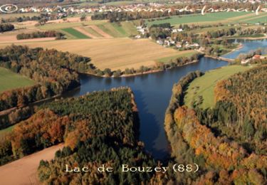
Départ prés de Girancourt, sur le pont du canal de l’Est (rue de Barbonfoing), ce trajet de 8 km vous amènera dans le petit village d’Agemont par des petits chemins entre champs et forêts.

Elevation profile

Photos

Positioning

Country:
France
Region :
Grand Est
Department/Province :
Vosges
Municipality :
Girancourt
Location:
Unknown
Start:(Dec)
Start:(UTM)
300090 ; 5336800 (32U) N.

Trails nearby

Trail Walking Chaumousey - Bouzey, côté abbaye  - Photo
Walking
triburemy

Walking

Medium
Chaumousey, Grand Est, Vosges, France
6.1 km | 7.5 km-effort
1h 40min
Yes
Trail Walking Sanchey - A la Découverte de BOUZEY - Photo
Walking
jeanclaude12

Walking

Very easy
Sanchey, Grand Est, Vosges, France
7.7 km | 9.3 km-effort
2h 4min
Yes
Trail Walking Sanchey - Circuit du tour du Lac de Bouzey - Photo
Walking
tracegps

Walking

Easy
Sanchey, Grand Est, Vosges, France
7 km | 8.5 km-effort
1h 40min
Yes
Trail Mountain bike Chaumousey - Espace VTT FFC Chemins du Coeur des Vosges - circuit n°87 - Circuit de l'Abbaye - Photo
Mountain bike
tracegps

Mountain bike

Medium
(1)
Chaumousey, Grand Est, Vosges, France
11.7 km | 14.8 km-effort
1h 0min
Yes
Trail Mountain bike Dommartin-aux-Bois - 2024-02-09_12h07m04_10178317_Le_Chanot_MAJ_ONF - Photo
Mountain bike
elgatolopez

Mountain bike

Difficult
Dommartin-aux-Bois, Grand Est, Vosges, France
31 km | 38 km-effort
2h 40min
Yes
Trail Walking Chaumousey - bouzey  - Photo
Walking
randolea

Walking

Medium
Chaumousey, Grand Est, Vosges, France
6.3 km | 7.3 km-effort
1h 27min
Yes
Trail Walking Chaumousey - Circuit du Fort de Girancourt - Photo
Walking
tracegps

Walking

Easy
Chaumousey, Grand Est, Vosges, France
5.1 km | 6.4 km-effort
1h 19min
Yes
Trail Walking Sanchey - Circuit de Chaumousey - Photo
Walking
tracegps

Walking

Medium
Sanchey, Grand Est, Vosges, France
14.7 km | 17 km-effort
2h 10min
Yes
Trail Walking Renauvoid - Circuit de Girancourt - Photo
Walking
tracegps

Walking

Easy
Renauvoid, Grand Est, Vosges, France
15.3 km | 19.8 km-effort
2h 30min
Yes


Close
My subscriptions