Trail Walking Épinal - Circuit de Bertraménil à l''Etang du Bult - Photo

Circuit de Bertraménil à l''Etang du Bult

 tracegps
tracegps

User

© OpenStreetMap contributors
Length
Length
11.2 km
Max alt
Max alt
496 m
Uphill gradient
Uphill gradient
269 m
Km-Effort
Km-Effort  
14.8 km
Min alt
Min alt
358 m
Downhill gradient
Downhill gradient
264 m
Boucle
Boucle
Yes
Creation date :
2014-12-10 00:00:00.0
Updated on :
2014-12-10 00:00:00.0

(0 Reviews)

Walking
Walking
1h30
Difficulty : Easy

Scan this QR Code to open this trail in the SityTrail application

FREE GPS app for hiking

Logo SityTrail SityTrail

IGN / Geographical institutes

Download SityTrail from the App Store Download SityTrail from Google Play

Logo SityTrail SityTrail World

The world is yours!

Download SityTrail from the App Store Download SityTrail from Google Play Download SityTrail on Huawei AppGallery

About

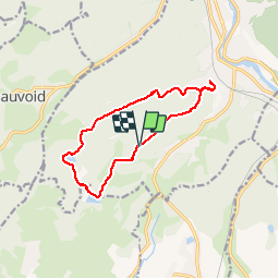
Trail Walking of 11.2 km to be discovered at Grand Est, Vosges, Épinal. This trail is proposed by tracegps.

Description

Depuis le centre d'Épinal, prendre la D434 en direction de Xertigny. Au deuxième feu tricolore après le supermarché Casino, prendre à droite. Vous passez sous un pont de chemin de fer pour rejoindre un petit parking portant un panneau d'information, point de départ du circuit. Depuis le parking, prendre la rue de la Devallée balisée (rond plein couleur vert) et (triangle plein couleur rouge) qui monte en direction du canal d'alimentation du lac de Bouzey. Prendre à droite le sentier rive droite qui longe le canal. Traverser le pont, prendre à droite le chemin des Murgères, monter vers la forêt sur 150 m, puis prendre à gauche le sentier balisé uniquement (triangle plein couleur rouge) intitulé "circuit des coteaux de Saint-Laurent".

Elevation profile

Photos

Positioning

Country:
France
Region :
Grand Est
Department/Province :
Vosges
Municipality :
Épinal
Location:
Unknown
Start:(Dec)
Start:(UTM)
308427 ; 5334344 (32U) N.

Trails nearby

Trail Walking Épinal - humbertois les ,2lacs - Photo
Walking
BernardHumeau

Walking

Medium
Épinal, Grand Est, Vosges, France
7.3 km | 8.9 km-effort
1h 55min
Yes
Trail Walking Épinal - ste Barbe - Photo
Walking
BernardHumeau

Walking

Very easy
Épinal, Grand Est, Vosges, France
6.7 km | 9 km-effort
1h 55min
Yes
Trail Walking Épinal - 2016 03 22 - Photo
Walking
michelbauby

Walking

Easy
Épinal, Grand Est, Vosges, France
8.9 km | 12.4 km-effort
3h 8min
Yes
Trail Other activity Épinal - Grand Est - Ligne 18,7 - Epinal Remiremont - Photo
Other activity
mich54

Other activity

Very easy
Épinal, Grand Est, Vosges, France
27 km | 31 km-effort
5min
No
Trail Walking Chantraine - De Chantraine à Bouzey - Photo
Walking
jeanclaude12

Walking

Easy
Chantraine, Grand Est, Vosges, France
14.6 km | 18.2 km-effort
3h 47min
Yes
Trail Walking Sanchey - A la Découverte de BOUZEY - Photo
Walking
jeanclaude12

Walking

Very easy
Sanchey, Grand Est, Vosges, France
7.7 km | 9.3 km-effort
2h 4min
Yes
Trail Walking Épinal - Aux Champs de Damas - Photo
Walking
jeanclaude12

Walking

Easy
(2)
Épinal, Grand Est, Vosges, France
8.4 km | 10.3 km-effort
2h 17min
Yes
Trail Walking Sanchey - Circuit du tour du Lac de Bouzey - Photo
Walking
tracegps

Walking

Easy
Sanchey, Grand Est, Vosges, France
7 km | 8.5 km-effort
1h 40min
Yes
Trail Mountain bike Uriménil - Espace VTT FFC Chemins du Pays d'Epinal, Coeur des Vosges - circuit n°99 - Chapuis Chantré - Photo
Mountain bike
tracegps

Mountain bike

Difficult
Uriménil, Grand Est, Vosges, France
28 km | 36 km-effort
2h 15min
Yes


Close
My subscriptions