Trail Walking Uxegney - Circuit d''Uxegney - Photo

Circuit d''Uxegney

 tracegps
tracegps

User

© OpenStreetMap contributors
Length
Length
12.8 km
Max alt
Max alt
390 m
Uphill gradient
Uphill gradient
173 m
Km-Effort
Km-Effort  
15.1 km
Min alt
Min alt
326 m
Downhill gradient
Downhill gradient
175 m
Boucle
Boucle
Yes
Creation date :
2014-12-10 00:00:00.0
Updated on :
2014-12-10 00:00:00.0

(1 Reviews)

Walking
Walking
3h30
Difficulty : Difficult

Scan this QR Code to open this trail in the SityTrail application

FREE GPS app for hiking

Logo SityTrail SityTrail

IGN / Geographical institutes

Download SityTrail from the App Store Download SityTrail from Google Play

Logo SityTrail SityTrail World

The world is yours!

Download SityTrail from the App Store Download SityTrail from Google Play Download SityTrail on Huawei AppGallery

About

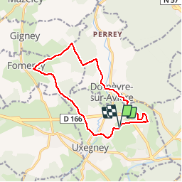
Trail Walking of 12.8 km to be discovered at Grand Est, Vosges, Uxegney. This trail is proposed by tracegps.

Description

Depuis le fort d'Uxegney partez à la découverte des villages de Domèvre-sur-Aviéres, Uxegney et Fomerey en passant par le Bois l'Abbé. Un circuit de 13 km au cœur de la forêt vosgienne.

Elevation profile

Photos

Positioning

Country:
France
Region :
Grand Est
Department/Province :
Vosges
Municipality :
Uxegney
Location:
Unknown
Start:(Dec)
Start:(UTM)
305717 ; 5341961 (32U) N.

Comments

Please log in to post a review or rate the element


Trails nearby

Trail sport Épinal - Golbey - Photo
sport
lebregien

sport

Very easy
(1)
Épinal, Grand Est, Vosges, France
7.1 km | 7.8 km-effort
Unknown
Yes
Trail Walking Chaumousey - Bouzey, côté abbaye  - Photo
Walking
triburemy

Walking

Medium
Chaumousey, Grand Est, Vosges, France
6.1 km | 7.5 km-effort
1h 40min
Yes
Trail Road bike Épinal - epinal florémont bouxières - Photo
Road bike
GuySimonin

Road bike

Medium
(1)
Épinal, Grand Est, Vosges, France
93 km | 110 km-effort
6h 26min
Yes
Trail Other activity Épinal - Grand Est - Ligne 18 - Epinal St Diè - Photo
Other activity
mich54

Other activity

Very easy
Épinal, Grand Est, Vosges, France
61 km | 68 km-effort
5min
No
Trail Other activity Épinal - Grand Est - Ligne 18,7 - Epinal Remiremont - Photo
Other activity
mich54

Other activity

Very easy
Épinal, Grand Est, Vosges, France
27 km | 31 km-effort
5min
No
Trail Walking Chantraine - De Chantraine à Bouzey - Photo
Walking
jeanclaude12

Walking

Easy
Chantraine, Grand Est, Vosges, France
14.6 km | 18.2 km-effort
3h 47min
Yes
Trail Walking Sanchey - A la Découverte de BOUZEY - Photo
Walking
jeanclaude12

Walking

Very easy
Sanchey, Grand Est, Vosges, France
7.7 km | 9.3 km-effort
2h 4min
Yes
Trail Walking Sanchey - Circuit du tour du Lac de Bouzey - Photo
Walking
tracegps

Walking

Easy
Sanchey, Grand Est, Vosges, France
7 km | 8.5 km-effort
1h 40min
Yes
Trail Mountain bike Épinal - Espace VTT FFC Chemins du Coeur des Vosges - circuit n°79 - Circuit des Forts - Photo
Mountain bike
tracegps

Mountain bike

Very difficult
Épinal, Grand Est, Vosges, France
98 km | 118 km-effort
10h 0min
Yes


Close
My subscriptions