Trail Walking Plougras - Autour de l''étang du Guic - Guerlesquin - Photo

Autour de l''étang du Guic - Guerlesquin

 tracegps
tracegps

User

© OpenStreetMap contributors
Length
Length
2.8 km
Max alt
Max alt
224 m
Uphill gradient
Uphill gradient
41 m
Km-Effort
Km-Effort  
3.3 km
Min alt
Min alt
185 m
Downhill gradient
Downhill gradient
43 m
Boucle
Boucle
Yes
Creation date :
2014-12-10 00:00:00.0
Updated on :
2014-12-10 00:00:00.0

(0 Reviews)

Walking
Walking
45m
Difficulty : Medium

Scan this QR Code to open this trail in the SityTrail application

FREE GPS app for hiking

Logo SityTrail SityTrail

IGN / Geographical institutes

Download SityTrail from the App Store Download SityTrail from Google Play

Logo SityTrail SityTrail World

The world is yours!

Download SityTrail from the App Store Download SityTrail from Google Play Download SityTrail on Huawei AppGallery

About

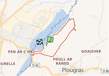
Trail Walking of 2.8 km to be discovered at Brittany, Côtes-d'Armor, Plougras. This trail is proposed by tracegps.

Description

Petite boucle à proximité de l'étang du Guic. Au début du parcours, le sentier d'accès au bois est assez raide sur 50 m. Prenez un petit sentier 150 à 200m avant.

Elevation profile

Photos

Positioning

Country:
France
Region :
Brittany
Department/Province :
Côtes-d'Armor
Municipality :
Plougras
Location:
Unknown
Start:(UTM)
457838 ; 5373753 (30U) N.

Trails nearby

Trail Walking Plougras - Autour de Plougras, abord de Guerlesquin - Photo
Walking
ollivier.albert

Walking

Easy
Plougras, Brittany, Côtes-d'Armor, France
8.7 km | 10.4 km-effort
2h 5min
Yes
Trail On foot Guerlesquin - L'Étang du Guic - Photo
On foot
PRO

On foot

Medium
Guerlesquin, Brittany, Finistère, France
15.9 km | 20 km-effort
4h 33min
Yes
Trail Walking Plougras - Eoliennes et étang de Beffou - Plougras - Photo
Walking
tracegps

Walking

Medium
Plougras, Brittany, Côtes-d'Armor, France
9.3 km | 11 km-effort
2h 19min
Yes
Trail Walking Plougras - Tro ar Guic - Plougras - Photo
Walking
tracegps

Walking

Medium
(1)
Plougras, Brittany, Côtes-d'Armor, France
8.1 km | 9.7 km-effort
2h 0min
Yes
Trail On foot Botsorhel - Botshorel Morlaix - Photo
On foot
chessyca

On foot

Difficult
Botsorhel, Brittany, Finistère, France
29 km | 35 km-effort
8h 3min
No
Trail On foot Botsorhel - 2022-04-02_21h02m45_SityTrail - 3150665 - et5xbotsorhelxmorlaix - Photo
On foot
chessyca

On foot

Difficult
Botsorhel, Brittany, Finistère, France
30 km | 36 km-effort
8h 10min
No
Trail Walking Guerlesquin - De Guerlesquin à la forêt de Beffou - Photo
Walking
tracegps

Walking

Very difficult
Guerlesquin, Brittany, Finistère, France
36 km | 44 km-effort
8h 0min
Yes
Trail Walking Guerlesquin - Autour de Guerlesquin et l'étang du Guic - Photo
Walking
tracegps

Walking

Difficult
Guerlesquin, Brittany, Finistère, France
22 km | 28 km-effort
4h 45min
Yes
Trail Walking Botsorhel - Botsirhel-Morlaix - Photo
Walking
aucamus

Walking

Very difficult
Botsorhel, Brittany, Finistère, France
30 km | 36 km-effort
9h 1min
No


Close
My subscriptions