Trail Walking Plougras - Autour de Plougras, abord de Guerlesquin - Photo

Autour de Plougras, abord de Guerlesquin

© OpenStreetMap contributors
Length
Length
8.7 km
Max alt
Max alt
244 m
Uphill gradient
Uphill gradient
125 m
Km-Effort
Km-Effort  
10.4 km
Min alt
Min alt
172 m
Downhill gradient
Downhill gradient
126 m
Boucle
Boucle
Yes
Creation date :
2023-05-21 13:48:16.258
Updated on :
2023-05-21 16:15:52.688

(0 Reviews)

Walking
Walking
2h05
Difficulty : Easy

Scan this QR Code to open this trail in the SityTrail application

FREE GPS app for hiking

Logo SityTrail SityTrail

IGN / Geographical institutes

Download SityTrail from the App Store Download SityTrail from Google Play

Logo SityTrail SityTrail World

The world is yours!

Download SityTrail from the App Store Download SityTrail from Google Play Download SityTrail on Huawei AppGallery

About

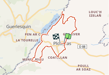
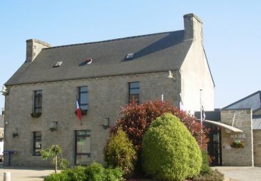
Trail Walking of 8.7 km to be discovered at Brittany, Côtes-d'Armor, Plougras. This trail is proposed by ollivier.albert.

Description

Belle rando avec nombreux sous-bois et panoramas magnifiques sur lesvallées environnantes

Elevation profile

Photos

Positioning

Country:
France
Region :
Brittany
Department/Province :
Côtes-d'Armor
Municipality :
Plougras
Location:
Unknown
Start:(UTM)
458468 ; 5373269 (30U) N.

Trails nearby

Trail On foot Guerlesquin - L'Étang du Guic - Photo
On foot
PRO

On foot

Medium
Guerlesquin, Brittany, Finistère, France
15.9 km | 20 km-effort
4h 33min
Yes
Trail Walking Plougras - Eoliennes et étang de Beffou - Plougras - Photo
Walking
tracegps

Walking

Medium
Plougras, Brittany, Côtes-d'Armor, France
9.3 km | 11 km-effort
2h 19min
Yes
Trail Walking Plougras - Tro ar Guic - Plougras - Photo
Walking
tracegps

Walking

Medium
(1)
Plougras, Brittany, Côtes-d'Armor, France
8.1 km | 9.7 km-effort
2h 0min
Yes
Trail On foot Botsorhel - Botshorel Morlaix - Photo
On foot
chessyca

On foot

Difficult
Botsorhel, Brittany, Finistère, France
29 km | 35 km-effort
8h 3min
No
Trail On foot Botsorhel - 2022-04-02_21h02m45_SityTrail - 3150665 - et5xbotsorhelxmorlaix - Photo
On foot
chessyca

On foot

Difficult
Botsorhel, Brittany, Finistère, France
30 km | 36 km-effort
8h 10min
No
Trail Walking Plougras - Autour de l''étang du Guic - Guerlesquin - Photo
Walking
tracegps

Walking

Medium
Plougras, Brittany, Côtes-d'Armor, France
2.8 km | 3.3 km-effort
45min
Yes
Trail Walking Guerlesquin - De Guerlesquin à la forêt de Beffou - Photo
Walking
tracegps

Walking

Very difficult
Guerlesquin, Brittany, Finistère, France
36 km | 44 km-effort
8h 0min
Yes
Trail Walking Guerlesquin - Autour de Guerlesquin et l'étang du Guic - Photo
Walking
tracegps

Walking

Difficult
Guerlesquin, Brittany, Finistère, France
22 km | 28 km-effort
4h 45min
Yes
Trail Walking Botsorhel - Botsirhel-Morlaix - Photo
Walking
aucamus

Walking

Very difficult
Botsorhel, Brittany, Finistère, France
30 km | 36 km-effort
9h 1min
No


Close
My subscriptions