


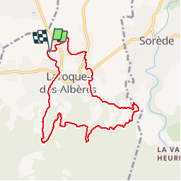
RP66 LAROQUE SOREDE LAROQUE

jeff66
User

1h40
Difficulty : Difficult

FREE GPS app for hiking
 SityTrail
IGN / Geographical institutes
SityTrail Plus
The world is yours!
About
Trail Walking of 9.6 km to be discovered at Occitania, Pyrénées-Orientales, Laroque-des-Albères. This trail is proposed by jeff66.
Description
RP66 LAROQUE - ch.de Tanya - cimetière de la rivière - ch. de La montagne, de la forge - SOREDE - maison de retraite - piste DFCI AL12 puis 12bis - LAROQUE - mas Bordes - canal - gué - chapelle de la Roca Vella - le 30.07.2019
Positioning
Comments