


SF 2019 - Pour le pique-nique, suivre la direction de la voie Agrippa - P2

Lucquiaud
User
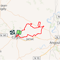

Length
94 km

Max alt
179 m

Uphill gradient
920 m
Km-Effort
106 km

Min alt
3 m

Downhill gradient
917 m
Boucle
Yes
Creation date :
2019-08-01 15:57:36.18
Updated on :
2019-08-01 15:57:58.138
6h15
Difficulty : Very difficult

FREE GPS app for hiking
 SityTrail
IGN / Geographical institutes
SityTrail Plus
The world is yours!
About
Trail Road bike of 94 km to be discovered at New Aquitaine, Charente, Cognac. This trail is proposed by Lucquiaud.
Positioning
Country:
France
Region :
New Aquitaine
Department/Province :
Charente
Municipality :
Cognac
Location:
Unknown
Start:(Dec)
Start:(UTM)
707007 ; 5063071 (30T) N.
Comments