


Camp Colomban 19 - jour 1

norbertmarteau
User
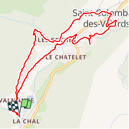

Length
5.9 km

Max alt
1263 m

Uphill gradient
199 m
Km-Effort
8.5 km

Min alt
1073 m

Downhill gradient
199 m
Boucle
Yes
Creation date :
2019-08-02 11:41:52.0
Updated on :
2019-08-02 19:39:10.81
1h33
Difficulty : Unknown

FREE GPS app for hiking
 SityTrail
IGN / Geographical institutes
SityTrail Plus
The world is yours!
About
Trail Walking of 5.9 km to be discovered at Auvergne-Rhône-Alpes, Savoy, Saint-Colomban-des-Villards. This trail is proposed by norbertmarteau.
Positioning
Country:
France
Region :
Auvergne-Rhône-Alpes
Department/Province :
Savoy
Municipality :
Saint-Colomban-des-Villards
Location:
Unknown
Start:(Dec)
Start:(UTM)
281266 ; 5018083 (32T) N.
Comments