


Pérignac 04-08-2019

jmrobin
User
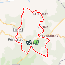

Length
9.3 km

Max alt
181 m

Uphill gradient
195 m
Km-Effort
11.9 km

Min alt
110 m

Downhill gradient
192 m
Boucle
Yes
Creation date :
2019-08-04 13:32:03.8
Updated on :
2019-08-04 16:53:21.396
1h46
Difficulty : Medium

FREE GPS app for hiking
 SityTrail
IGN / Geographical institutes
SityTrail Plus
The world is yours!
About
Trail Walking of 9.3 km to be discovered at New Aquitaine, Charente, Pérignac. This trail is proposed by jmrobin.
Positioning
Country:
France
Region :
New Aquitaine
Department/Province :
Charente
Municipality :
Pérignac
Location:
Unknown
Start:(Dec)
Start:(UTM)
272329 ; 5038121 (31T) N.
Comments