


variante Chataignoux

JoelHerve
User

Length
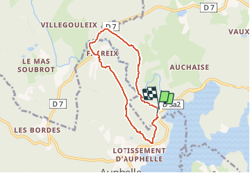
6.9 km

Max alt
705 m

Uphill gradient
169 m
Km-Effort
9.2 km

Min alt
595 m

Downhill gradient
177 m
Boucle
Yes
Creation date :
2014-12-10 00:00:00.0
Updated on :
2014-12-10 00:00:00.0
2h22
Difficulty : Easy

FREE GPS app for hiking
 SityTrail
IGN / Geographical institutes
SityTrail Plus
The world is yours!
About
Trail Walking of 6.9 km to be discovered at New Aquitaine, Creuse, Royère-de-Vassivière. This trail is proposed by JoelHerve.
Positioning
Country:
France
Region :
New Aquitaine
Department/Province :
Creuse
Municipality :
Royère-de-Vassivière
Location:
Unknown
Start:(Dec)
Start:(UTM)
410564 ; 5073913 (31T) N.
Comments
Randonnée facile malgré quelques belles montées dans un cadre naturel très agréable.