Trail Walking Sentheim - Knapphutte Saegenkopf Hutte - Photo

Knapphutte Saegenkopf Hutte

 helmut68
helmut68

User

© OpenStreetMap contributors
Length
Length
11.2 km
Max alt
Max alt
534 m
Uphill gradient
Uphill gradient
267 m
Km-Effort
Km-Effort  
14.8 km
Min alt
Min alt
353 m
Downhill gradient
Downhill gradient
265 m
Boucle
Boucle
Yes
Creation date :
2019-08-08 08:44:21.609
Updated on :
2019-08-10 09:12:35.862

(0 Reviews)

Walking
Walking
2h58
Difficulty : Easy

Scan this QR Code to open this trail in the SityTrail application

FREE GPS app for hiking

Logo SityTrail SityTrail

IGN / Geographical institutes

Download SityTrail from the App Store Download SityTrail from Google Play

Logo SityTrail SityTrail Plus

The world is yours!

Download SityTrail from the App Store Download SityTrail from Google Play Download SityTrail on Huawei AppGallery

About

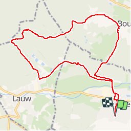
Trail Walking of 11.2 km to be discovered at Grand Est, Haut-Rhin, Sentheim. This trail is proposed by helmut68.

Description

Départ place de l'église , traverser Sentheim et la Doller . Ensuite prendre le balisage rectangle " rouge blanc rouge" jusqu'au parcours vitæ de Bourbach le Bas , là choisir le balisage disque " jaune " direction Knapphutte , puis Saegenkopf Hutte où un abri en bois et un barbecue vous attend pour la pause repas ...
Ensuite prendre la direction Lauw , balisée disque " jaune ".
A la sortie de la forêt et l'entrée de Lauw tourner à gauche ( 100 m ) pour suivre le triangle " bleu " jusqu'à Sentheim.


Elevation profile

Positioning

Country:
France
Region :
Grand Est
Department/Province :
Haut-Rhin
Municipality :
Sentheim
Location:
Unknown
Start:(UTM)
353918 ; 5290619 (32T) N.


Close
My subscriptions