


13 08

JPS73
User
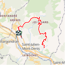

Length
12.8 km

Max alt
1614 m

Uphill gradient
1111 m
Km-Effort
28 km

Min alt
662 m

Downhill gradient
1218 m
Boucle
No
Creation date :
2019-08-13 06:52:50.173
Updated on :
2019-08-13 13:58:07.915
6h12
Difficulty : Very easy

FREE GPS app for hiking
 SityTrail
IGN / Geographical institutes
SityTrail Plus
The world is yours!
About
Trail Walking of 12.8 km to be discovered at Auvergne-Rhône-Alpes, Savoy, Saint-Julien-Mont-Denis. This trail is proposed by JPS73.
Positioning
Country:
France
Region :
Auvergne-Rhône-Alpes
Department/Province :
Savoy
Municipality :
Saint-Julien-Mont-Denis
Location:
Unknown
Start:(Dec)
Start:(UTM)
297760 ; 5014482 (32T) N.
Comments