


boucle st Hippolyte-ht koenigsburg-st Hippolyte

fbienmuller
User
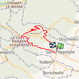

Length
12.4 km

Max alt
738 m

Uphill gradient
517 m
Km-Effort
19.3 km

Min alt
251 m

Downhill gradient
515 m
Boucle
Yes
Creation date :
2019-08-14 07:57:10.126
Updated on :
2019-08-14 11:36:13.68
3h22
Difficulty : Easy

FREE GPS app for hiking
 SityTrail
IGN / Geographical institutes
SityTrail Plus
The world is yours!
About
Trail Walking of 12.4 km to be discovered at Grand Est, Haut-Rhin, Saint-Hippolyte. This trail is proposed by fbienmuller.
Photos


Positioning
Country:
France
Region :
Grand Est
Department/Province :
Haut-Rhin
Municipality :
Saint-Hippolyte
Location:
Unknown
Start:(Dec)
Start:(UTM)
378614 ; 5343392 (32U) N.
Comments