


GLIERES: MONUMENT - CHALETS DES AUGES - GAUTARD

djeepee74
User
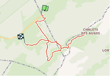

Length
8.8 km

Max alt
1797 m

Uphill gradient
419 m
Km-Effort
14.5 km

Min alt
1391 m

Downhill gradient
468 m
Boucle
No
Creation date :
2019-08-14 17:22:52.63
Updated on :
2020-01-08 11:10:14.594
3h00
Difficulty : Easy

FREE GPS app for hiking
 SityTrail
IGN / Geographical institutes
SityTrail Plus
The world is yours!
About
Trail Walking of 8.8 km to be discovered at Auvergne-Rhône-Alpes, Upper Savoy, Fillière. This trail is proposed by djeepee74.
Description
SEMI BOUCLE... il vous faudra remonter chercher votre véhicule au col des Glières
Positioning
Country:
France
Region :
Auvergne-Rhône-Alpes
Department/Province :
Upper Savoy
Municipality :
Fillière
Location:
Thorens-Glières
Start:(Dec)
Start:(UTM)
293240 ; 5093767 (32T) N.
Comments
super