


Lac de l'âne départ pont du Rieu-claret

ezorzet
User
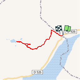

Length
6.5 km

Max alt
2432 m

Uphill gradient
695 m
Km-Effort
15.8 km

Min alt
1754 m

Downhill gradient
697 m
Boucle
Yes
Creation date :
2019-08-18 06:56:08.293
Updated on :
2019-08-18 16:43:33.365
5h37
Difficulty : Difficult

FREE GPS app for hiking
 SityTrail
IGN / Geographical institutes
SityTrail Plus
The world is yours!
About
Trail Walking of 6.5 km to be discovered at Auvergne-Rhône-Alpes, Savoy, Saint-Colomban-des-Villards. This trail is proposed by ezorzet.
Description
Magnifique randonnée, vue sur lac Grand-Maison.
Photos


32 photos in total. Please click on a photo to see them all in the gallery.
Positioning
Country:
France
Region :
Auvergne-Rhône-Alpes
Department/Province :
Savoy
Municipality :
Saint-Colomban-des-Villards
Location:
Unknown
Start:(Dec)
Start:(UTM)
275432 ; 5011869 (32T) N.
Comments
