Trail Walking Beyssac - Moulin de Lignac - Photo
 houbart
houbart

User

© OpenStreetMap contributors
Length
Length
6.9 km
Max alt
Max alt
391 m
Uphill gradient
Uphill gradient
174 m
Km-Effort
Km-Effort  
9.2 km
Min alt
Min alt
312 m
Downhill gradient
Downhill gradient
174 m
Boucle
Boucle
Yes
Creation date :
2019-08-20 11:58:33.873
Updated on :
2019-08-20 12:13:09.646

(0 Reviews)

Walking
Walking
1h58
Difficulty : Medium

Scan this QR Code to open this trail in the SityTrail application

FREE GPS app for hiking

Logo SityTrail SityTrail

IGN / Geographical institutes

Download SityTrail from the App Store Download SityTrail from Google Play

Logo SityTrail SityTrail World

The world is yours!

Download SityTrail from the App Store Download SityTrail from Google Play Download SityTrail on Huawei AppGallery

About

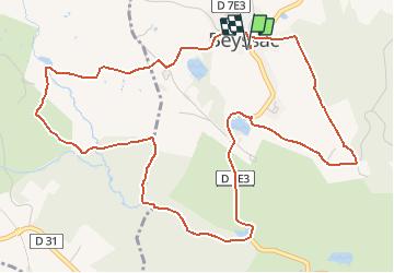
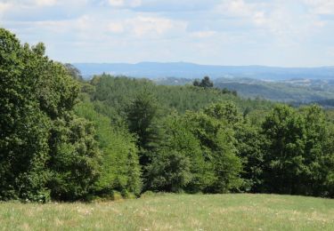
Trail Walking of 6.9 km to be discovered at New Aquitaine, Corrèze, Beyssac. This trail is proposed by houbart.

Description

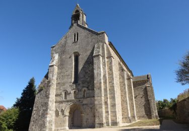
Départ de l'église construite par le pape Innocent VI au XIVe siècle. En chemin, le domaine de la Rivière, ancienne jumenterie du haras national. Une tour du château est recouverte de chaume.

Elevation profile

Positioning

Country:
France
Region :
New Aquitaine
Department/Province :
Corrèze
Municipality :
Beyssac
Location:
Unknown
Start:(UTM)
374974 ; 5025353 (31T) N.

Trails nearby

Trail Walking Lascaux - La Tine - Lascaux - Photo
Walking
houbart

Walking

Medium
(1)
Lascaux, New Aquitaine, Corrèze, France
8.3 km | 11.9 km-effort
2h 35min
Yes
Trail Running Saint-Sornin-Lavolps - jour 21 CAP Jeanot - Photo
Running
jeannat

Running

Very easy
Saint-Sornin-Lavolps, New Aquitaine, Corrèze, France
41 km | 52 km-effort
6h 24min
No
Trail Walking Arnac-Pompadour - Arnac-Pompadour - Photo
Walking
houbart

Walking

Very easy
(2)
Arnac-Pompadour, New Aquitaine, Corrèze, France
7.5 km | 9.2 km-effort
2h 2min
Yes
Trail Walking Troche - Le chemin des étangs au départ de Troche - Photo
Walking
houbart

Walking

Medium
Troche, New Aquitaine, Corrèze, France
7.2 km | 9.5 km-effort
1h 58min
Yes
Trail On foot Saint-Sornin-Lavolps - Forêt Domaniale de Pompadour par Saint-Sornin-Lavolps - Photo
On foot
houbart

On foot

Very easy
Saint-Sornin-Lavolps, New Aquitaine, Corrèze, France
8.6 km | 10.8 km-effort
Unknown
Yes
Trail Walking Arnac-Pompadour - Arnac-Pompadour- Domaine de Chignac - Photo
Walking
houbart

Walking

Easy
Arnac-Pompadour, New Aquitaine, Corrèze, France
6.2 km | 7.7 km-effort
1h 43min
Yes
Trail Walking Beyssac - Beyssac (19230)- Chartreuse du Glandier et Canal des moines - Photo
Walking
houbart

Walking

Very easy
(1)
Beyssac, New Aquitaine, Corrèze, France
4.6 km | 6.4 km-effort
1h 13min
Yes
Trail Walking Concèze - Concèze- Les vignes - Photo
Walking
houbart

Walking

Easy
(1)
Concèze, New Aquitaine, Corrèze, France
6.6 km | 8.8 km-effort
2h 6min
Yes
Trail Quad Troche - première reconnaissance  - Photo
Quad
AQT

Quad

Easy
(1)
Troche, New Aquitaine, Corrèze, France
93 km | 117 km-effort
5h 8min
Yes


Close
My subscriptions