


PR-La tour Faudé

JMCMoreau
User
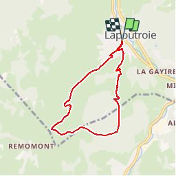

Length
6.1 km

Max alt
678 m

Uphill gradient
255 m
Km-Effort
9.5 km

Min alt
424 m

Downhill gradient
255 m
Boucle
Yes
Creation date :
2019-08-20 12:09:42.329
Updated on :
2019-08-20 12:13:43.821
2h15
Difficulty : Easy

FREE GPS app for hiking
 SityTrail
IGN / Geographical institutes
SityTrail Plus
The world is yours!
About
Trail Walking of 6.1 km to be discovered at Grand Est, Haut-Rhin, Lapoutroie. This trail is proposed by JMCMoreau.
Description
La tour Faudé mais sans dénivelé pour les PR.
Positioning
Country:
France
Region :
Grand Est
Department/Province :
Haut-Rhin
Municipality :
Lapoutroie
Location:
Unknown
Start:(Dec)
Start:(UTM)
363767 ; 5334864 (32U) N.
Comments