Trail Walking Limeyrat - Limeyrat Peira Levada 11km - Photo

Limeyrat Peira Levada 11km

 YV24
YV24

User

© OpenStreetMap contributors
Length
Length
10.3 km
Max alt
Max alt
238 m
Uphill gradient
Uphill gradient
166 m
Km-Effort
Km-Effort  
12.5 km
Min alt
Min alt
142 m
Downhill gradient
Downhill gradient
166 m
Boucle
Boucle
Yes
Creation date :
2019-08-20 17:56:41.223
Updated on :
2022-11-06 09:35:37.879

(2 Reviews)

Walking
Walking
2h46
Difficulty : Difficult

Scan this QR Code to open this trail in the SityTrail application

FREE GPS app for hiking

Logo SityTrail SityTrail

IGN / Geographical institutes

Download SityTrail from the App Store Download SityTrail from Google Play

Logo SityTrail SityTrail World

The world is yours!

Download SityTrail from the App Store Download SityTrail from Google Play Download SityTrail on Huawei AppGallery

About

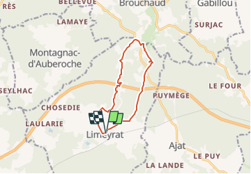
Trail Walking of 10.3 km to be discovered at New Aquitaine, Dordogne, Limeyrat. This trail is proposed by YV24.

Description

Boucle PDIPR de Peira Levada
Boucle bien tracée, balisée et panneautée.
Circuit varié et vallonné, chemins souvent larges, peu de route.
Praticable en tout temps.
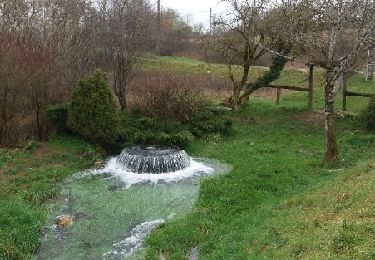
Après de fortes pluies, la résurgence du Puits de Bontemps est active.
Dolmen Pierre Levée vers le km 4

Elevation profile

Positioning

Country:
France
Region :
New Aquitaine
Department/Province :
Dordogne
Municipality :
Limeyrat
Location:
Unknown
Start:(UTM)
341310 ; 5002724 (31T) N.

Comments

Please log in to post a review or rate the element


Trails nearby

Trail Walking Limeyrat - limeyrat - Photo
Walking
fab0202

Walking

Easy
Limeyrat, New Aquitaine, Dordogne, France
11.1 km | 13.3 km-effort
2h 48min
Yes
Trail Mountain bike Ajat - reco 3 romain thenon - Photo
Mountain bike
phil24

Mountain bike

Easy
Ajat, New Aquitaine, Dordogne, France
19.1 km | 23 km-effort
2h 3min
Yes
Trail Mountain bike Ajat - reco 3 romain thenon - Photo
Mountain bike
phil24

Mountain bike

Easy
Ajat, New Aquitaine, Dordogne, France
19.1 km | 23 km-effort
2h 3min
Yes
Trail Walking Montagnac-d'Auberoche - Boucle de la fontaine Marceau ( Montagnac d’ Auberoche)  - Photo
Walking
Marc 24

Walking

Easy
Montagnac-d'Auberoche, New Aquitaine, Dordogne, France
6.9 km | 8.6 km-effort
2h 9min
Yes
Trail Walking Ajat - Beauzens Rozas La Rolfie 12km - Photo
Walking
YV24

Walking

Easy
Ajat, New Aquitaine, Dordogne, France
11.7 km | 14.3 km-effort
2h 54min
Yes
Trail Walking Brouchaud - Rousselle - Photo
Walking
phplatteau44

Walking

Very easy
Brouchaud, New Aquitaine, Dordogne, France
5.6 km | 7.2 km-effort
1h 35min
Yes
Trail Walking Ajat - Bauzens Patrimoine - Photo
Walking
NICOLEROBERT

Walking

Very easy
Ajat, New Aquitaine, Dordogne, France
10.4 km | 13 km-effort
3h 3min
Yes
Trail Road bike Brouchaud - Php010819 - Photo
Road bike
phplatteau44

Road bike

Medium
Brouchaud, New Aquitaine, Dordogne, France
20 km | 25 km-effort
1h 13min
Yes
Trail Road bike Brouchaud - Php300719 - Photo
Road bike
phplatteau44

Road bike

Medium
Brouchaud, New Aquitaine, Dordogne, France
20 km | 0 m-effort
1h 10min
Yes


Close
My subscriptions