


Tour de la Vanoise

drarep
User
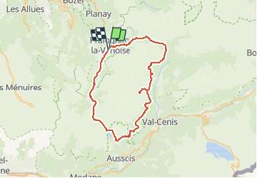

Length
62 km

Max alt
2914 m

Uphill gradient
3428 m
Km-Effort
108 km

Min alt
1424 m

Downhill gradient
3445 m
Boucle
Yes
Creation date :
2019-08-20 20:21:10.459
Updated on :
2019-08-20 20:27:31.178
22h15
Difficulty : Very difficult

FREE GPS app for hiking
 SityTrail
IGN / Geographical institutes
SityTrail Plus
The world is yours!
About
Trail Walking of 62 km to be discovered at Auvergne-Rhône-Alpes, Savoy, Pralognan-la-Vanoise. This trail is proposed by drarep.
Positioning
Country:
France
Region :
Auvergne-Rhône-Alpes
Department/Province :
Savoy
Municipality :
Pralognan-la-Vanoise
Location:
Unknown
Start:(Dec)
Start:(UTM)
321259 ; 5027061 (32T) N.
Comments